This article is republished with permission from Wonder Tools, a newsletter that helps you discover the most useful sites and apps. Subscribe here.
PamPam, Felt, and Proxi are new tools that make it easier to create, share, and publish attractive online maps. You can use them to visualize itineraries, to map out your favorite restaurants, or for data-journalism projects. Whipping up maps has gotten faster, more visual, and more fun.
PamPam: Create colorful, shareable maps
PamPam gives you a fun, free way to create maps to share with friends. It’s ideal for spinning up a quick map of recommended playgrounds or monuments you’d like to visit.
Best features
- PamPam uses AI to suggest place descriptions and to identify locations even if you don’t know have an address.
- The playful aesthetic makes it fun to use. You can add annotations with drawings, text, or stickers.
- Live collaborative editing means you and your friends can make a map together just as you would work in Google Doc.
- It’s super easy to create a new map by importing a list of places. You can paste in anything from your clipboard, or a Google My Maps link, an Airtable database, or any link that has places on it.
- I tested it by pasting in a link to this messy site listing NYC violin makers and instantly got this nice map.
- I also tested importing addresses from a Google sheet (originally made by Sergio Spagnuolo) and got a nice map of NYC media headquarters as of 2016, complete with colorful icons.
- If you have a Notion page or any other link with addresses on it, you can import it in seconds. Or just copy and paste a list of addresses.
- Pricing: Free for up to 3 maps with 150 spots. $12-$25/monthly for embedding, more maps, and additional premium features.
Map Examples
Each of the 3 maps below took me just a few minutes to make:
- NYC Midtown spots for lunch or tea meetings
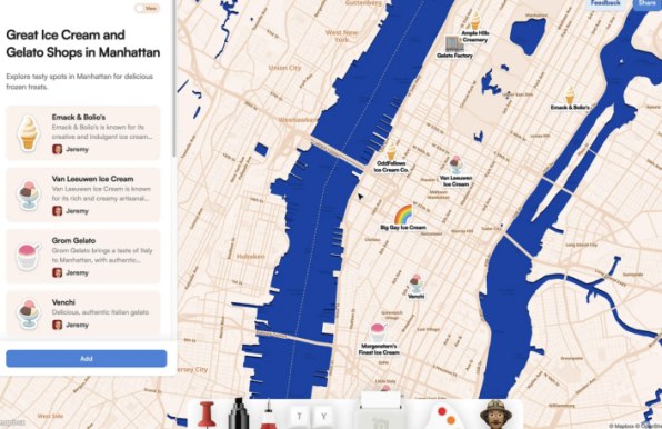
- The best Manhattan ice cream and gelato spots
- 10 NYC parks and open spaces I created with PamPam’s AI. I simply asked it to create a map of “parks and open spaces all around New York City.”
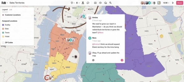
Felt: Advanced maps for professional use
Felt is a modern, collaborative map-making tool that’s more advanced and complex than PamPam. The browser-based platform allows you to create, annotate, modify, and visualize data. You can import just about any kind of map data—including KML, CSV, Excel, Zip, or GeoJSON files. And you can share what you create privately or publicly for free.
- Gallery: Check out cool example maps, or look at this super tutorial map. Another example: Look back at the NYC media headquarters in 2016.
- Pricing: Free for unlimited map creation and sharing, or $30/month for advanced features including image and PDF exports and embedded maps.
- Learn more. Watch Felt’s 60-minute ">video tutorial or a ">series of short intro videos.
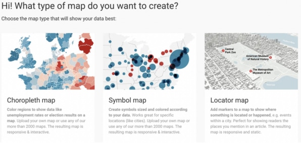
Datawrapper: Journalistic maps
Datawrapper makes it easy to create your own maps whether you have a small list of places or a gigantic dataset. You don’t need any technical skills to use it. And it’s easy to make something look nice even if you’re not a designer. Datawrapper’s map descriptions can help you figure out which kind of map to create.
- Pricing: Free for almost all use.
- Chloropleth maps let you color-code a map based on how common something is in a particular place. This works for showing things like regional incidence of a disease, geographic breakdown of voting, or income by location.
- Symbol maps are useful for showing hotspots. I used this map type to show application origins for a 2020 cohort of the Journalism Creators Program I lead.
- Locator maps let you drop pins on a map to spotlight particular locations. This works well to show a few specific spots impacted by something, wheelchair accessible subway stops, for instance, or the places most impacted by a new policy.
Proxi: Mapping with community features
Proxi is a useful new service for creating and sharing visual maps that has special features for businesses and anyone creating community events.
- You can use it to create public maps for community gatherings, to share wedding events with guests, or to show historical events on a map.
- If you have a business or organization, collect visitor info with pop-up forms.
- Gamify your map by creating check-in spots, with points awarded for visiting places.
- Pricing: Free 7-day trial, then $9/month or more depending on features. Free for teachers and nonprofits.
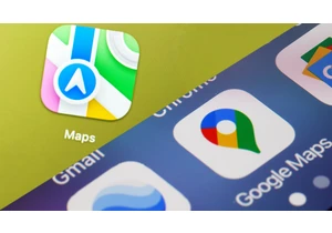
Google’s My Maps: Simple, traditional
Google My Maps lets you make a map to share from your existing Google account. It’s easy to use, but doesn’t have the advanced features of Felt or the social and design elements in Proxi or PamPam.
- Example: Create my favorite spots for visitors to NYC.
- Best feature: It’s easy to look up places and add them to your map.
- Pricing: Completely free.
What tool to pick?
- Felt, Datawrapper, and Flourish are great for journalism maps with big datasets because they have advanced features and lots of customization.
- Proxi is great for small businesses and community organizers because it has pop-up forms for capturing information from visitors and metrics.
- PamPam is best for individuals sharing maps socially because it’s easy, fast, free, and the resulting maps are clear and visually engaging.
Other useful mapping tools
- StoryMap: Create map-driven stories by highlighting where a series of events occurred, like the most expensive football transfers. StoryMap is part of a great suite of tools from Northwestern’s Knight Lab. Here’s my post on why they’re worth trying.
- MapChart: Create custom maps showing patterns across countries, like the percentage of women in national parliaments or iOS vs. Android global popularity.
- FreeMapTools: Find the distance between two places, calculate the area of a place you draw on a map, or pick from dozens of other mapping resources.
This article is republished with permission from Wonder Tools, a newsletter that helps you discover the most useful sites and apps. Subscribe here.
Connectez-vous pour ajouter un commentaire
Autres messages de ce groupe

The role of the CFO is evolving—and fast. In today’s volatile business environment, finance leaders are navigating everything from unpredictable tariffs to tightening regulations and rising geopol
In June, Google released its newest smartphone operating system, Android 16. The same month, Apple previewed its next smartphone oper

I’ve worked at the bleeding edge of robotics innovation in the United States for almost my entire professional life. Never before have I seen another country advance so quickly.
In

Restaurant industry leaders are excited for